
Energy Resources for the Isle of Navitas
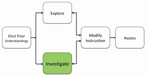
Students will explore energy resources for one of three provinces on the Isle of Navitas. They will analyze the benefits, costs, and environmental impacts of each energy source. Students will analyze energy resources for the island and develop an energy policy statement. The policy will recommend an efficient combination of energy sources to provide sufficient power to the province while minimizing environment impacts. Students will apply and use GIS tools and knowledge from past activities to make decisions for the placement of power plants in their province.
IMPORTANT NOTE: Prior to implementing this activity with your students, please refer to the
- Investigating Energy Resources for the Isle of Navitas with My World GIS or Web GIS Teacher Guide
- Investigating Energy Resources for the Isle of Navitas Assessments for each province
- Visual Guides to Assess the Isle of Navitas Activity for each province to assist you with additional content knowledge about this activity.
Note: This instructional sequence focuses primarily on teaching with My World GIS. Please consult the Investigating Energy Resources for the Isle of Navitas with Web GIS Teacher Guide below for instructional support for teaching with the Isle of Navitas Web GIS.
Video overviews of the learning activity are located below in the Teacher Resources/Content Support section of this Web page. These overviews show how to use the GIS for data analysis in the investigation. You may wish to show your students an overview video as you introduce the learning activity.
- Ask students what factors must be put into consideration when planning for an efficient energy policy? Prompt students to think about issues such as production costs, transportation, and environmental impacts.
- Inform students that this is a five-day activity in which they will first analyze energy resources for a province on the Isle of Navitas. They will then develop (1) an energy policy that will provide sufficient power for a province while minimizing the environmental impact, and (2) a short 5-minute PowerPoint presentation to present their proposed energy policy. They will present their energy policy and justify why their combination of energy sources will promote energy efficiency for the island population.
- Introduce the term "efficient energy policy" and explain to students that an energy policy is a statement of government policy to address issues of energy development including energy production, distribution and consumption. An energy policy is used to determine from where the future energy sources in a province will come.
- Present an overview of the Isle of Navitas activity to the students. Explain that they are the chief energy officer (CEO) of one of three provinces on the Isle of Navitas. It has a population of about 7,000,000 people. Their task is to explore the energy resources in their province using My World GIS and to recommend an efficient combination of energy sources that will minimize the impact on the environment. They will:
a) Explore energy resources for the Isle of Navitas.
b) Analyze the benefits and costs of each energy source.
c) Analyze the environmental impacts of each energy source.
d) Recommend an efficient combination of energy sources for their province.
- Divide students in groups of 3s. Assign each student team a province in the Isle of Navitas. Provide each student with:
A) Investigating Energy Resources for the Isle of Navitas with My World GIS or Web GIS Student Handout
B) Investigating Energy Resources for the Isle of Navitas with My World GIS or Web GIS Student Investigation Sheet
NOTE: The province of Cambria is the only province that does not require importing additional energy to meet its energy consumption needs. You may wish to assign this province to lower-ability level students in your classroom.
- Instruct students to write the name of their province on their investigation sheet.
- Instruct students to download the Navitas_Isle.m3vz file from the Student Resources Web page and open the it in My World GIS.
- Display the Isle of Navitas GIS map to the front of the room with an LCD projector. Show students where Iberia, Gaul, and Cambria are located on the GIS.
- Highlight the different data layers on the GIS and model to students how to view the different energy sources.
- Instruct student groups to explore the energy resources for their province and answer the questions on their investigation sheets for each energy resource. Guide students as they perform the task.
Implementation suggestions:
- For classes with students with special needs, you may wish to provide additional modeling, prompts and guidance for each energy source. You may wish to guide students through each question for the first energy source on the investigation sheet (hydroelectric power) before continuing to the next energy source (tidal energy).
- Show students examples of a good location on a river to locate a dam to produce hydroelectric energy and another location on the same river that would not be a good location to build a dam for a hydroelectric power plant. Emphasize to students that areas that do not have changes in elevation or are not located near a confluence in a river are not optimal locations to place a dam.
- In some provinces, renewable resources exist in areas of natural significance. You may wish to highlight an example (such as high wind speed areas and geothermal areas in Gaul) to discuss with students the trade-offs for acquiring a renewable resource in an area of natural significance.
- Ask students if they have any questions regarding the activity and respond to their questions.
- Have students close and not save any changes they made to the My World GIS file when they finish (if other students in later classes will use the file).
Materials Needed:
My World Handouts
(1) Investigating Energy Resources for the Isle of Navitas with My World GIS Teacher Guide (PDF / MS Word)
(2) Investigating Energy Resources for the Isle of Navitas with My World GIS Student Handout (PDF / MS Word)
My World GIS File
Navitas_Isle (M3VZ)
Web GIS Handouts
(1) Investigating Energy Resources for the Isle of Navitas with Web GIS Teacher Guide (PDF / MS Word)
(2) Investigating Energy Resources for the Isle of Navitas with Web GIS Student Handout (PDF / MS Word)
Web GIS
Assessment Information
Investigating Energy Resources for the Isle of Navitas Assessment-Province of Cambria (PDF / MS Word)
Visual Guide to Assess the Isle of Navitas Activity-Province of Cambria (PDF)
Investigating Energy Resources for the Isle of Navitas Assessment-Province of Gaul (PDF / MS Word)
Visual Guide to Assess the Isle of Navitas Activity-Province of Gaul (PDF)
Investigating Energy Resources for the Isle of Navitas Assessment-Province of Iberia (PDF / MS Word)
Visual Guide to Assess the Isle of Navitas Activity-Province of Iberia (PDF)
Teacher Resources/Content Support
Web GIS Isle of Navitas Tutorial (QuickTime Video)